• Home
• Latest News
• Donations
• Trails (including Trail Closures)
• Get Involved
• Directions
• Events
• History
• Partners
• Gallery
• Mosaic
• Contact Us
Upcoming Events:
Events:
Sat, Sept 27 - Trailwork
Weds, Oct 8 - Ivy removal
Sat, Oct 25 - No Ivy Day
Weds, Nov 12 - Raking
Sat, Nov 22 - Raking
For details
Trails
TRAIL CLOSURES
See: Portland Parks & Recreation Trail Closures and Delays
September 2024
The Summit Trail from Council Crest to Talbot and the Marquam Trail from Patton Road to Highway 26 are now open!


Suggested Hikes
Wildwood Trail/Forestry Center To Council Crest - 1.8 mi. one way
The north end of Marquam Trail begins where it leaves the Wildwood Trail on the hill above and northwest of the Vietnam Memorial. It heads south, circling above and to the west of the Forestry Center. The route is not always clear as the trail meanders across small open meadows. It drops down a steep slope into the woods at the rear of the Children's Museum and comes out of the woods near the north end of the overpass at the freeway ramps.
Cross the overpass to the top of eastbound on-ramp of Sunset Highway. The trail follows a narrow paved sidewalk past the bus stop and down the freeway on-ramp. Halfway down the ramp it ducks to the right into the woods and begins a steep climb up the hill. After .75 mi. the trail reaches Patton Rd. about 100 ft. east of the intersection with Humphrey Blvd. (Talbot Rd. to the south.) Turn right (uphill) to reach the intersection.
Turn left at the blinking light, pass the gas station, and stay on the shoulder, following Talbot to the edge of Council Crest Park. Pedestrians should stay close to the edge of the road: The curve is blind, traffic is fast, and the street is narrow. At the intersection of Fairmount Blvd. and Council Crest Park pedestrians must cross over Fairmount and proceed between the wooden posts and up the hill on the paved trail. Look for the historical plaque on the left identifying the old Council Crest Trolley stop. Marquam Trail is well marked just ahead. It turns to the left, up the stairs, and circles around and under the summit. The paved path on the old road straight ahead goes directly to the summit.
Continue on Marquam Trail for about .25 mile, to the next signpost. A short uphill climb to the right also brings you to the summit of Council Crest. Excellent views, parking, trash receptacles, and water are available.
North Marquam Nature Park Loop - 1.2 mi round trip
This loop trail traverses both sides of what historically has been called the Marquam Gulch, a deeply incised ravine that cuts up through a portion of Portland’s West Hills. While this loop trail now passes through a lovely mature Douglas fir Forest, this ravine was logged in about the 1880s. The only evidence of this logging now are a couple of old cedar stumps in the upper portion of the ravine that have springboard notches cut into them (cedar being the only type of stump that would not have rotted away by now since being logged). At one time, a stream (Caruthers Creek) flowed down the base of the ravine to the Willamette River. But Caruthers Creek is no more as it has been diverted into a sewer pipe constructed in 1912. You may catch glimpses of this 30-inch diameter pipe where it is present above ground in the base of the ravine. Caruthers Creek was the source of early Portland’s fresh water supply from about 1856 to 1884, which was a primitive network of fir log pipes laid from Marquam Gulch to downtown Portland.
Approaching the Marquam Shelter from the parking lot, continue straight up the hill past the Marquam Mosaic (not to the left, which is the Basalt Trail). Take the first right turn onto the Sunnyside Trail. The first 100 yards of this trail passes through what was once a small neighborhood of up to eight residences from the 1890s to the 1970s. Many of those that lived here were Italian immigrants and their descendants. There is still evidence of some house foundations across the way, as well as the fruit and hazelnut trees they had planted, including an Italian plum that borders the trail. Proceed up the north side of the ravine into the Douglas fir forest enjoying the native plants and noticing that there is less invasive ivy in this part of the park. There has been a great deal of volunteer and Parks staff work here over the years clearing ivy and replanting with a diversity of native plants.
Continue uphill about 0.4 miles where you will meet the Broadway Trail junction. Stay on the Sunnyside Trail crossing two bridges over small creeks that flow most of the year until you reach the intersection of the Marquam Trail. Continuing uphill to the right, the Marquam Trail would take you to Council Crest. On this hike we will turn to the left on the Marquam Trail. Around the corner you will descend in a series of switchbacks. This trail has been reinforced with fencing to keep people and dogs from cutting switchbacks, a practice that is unsafe and causes soil erosion and trampling of plants. At the next intersection, turn to your left onto the Shadyside Trail to complete the 1.2-mile loop back down the south side of the ravine to the Marquam Shelter.
For a longer 1.6-mile loop continue straight on the Marquam Trail. You will round a ridge and after about 0.5 miles reach a small staircase down to the Basalt Trail. Turn left. The trail follows a steep and rocky old road, now used as a maintenance road for buried sewer and water lines. In about 0.3 miles you will return to the Marquam Shelter. Here, take time to observe the Marquam Mosaic, a 2013 art project that involved over 400 community members, and created the beautiful mosaic walls featuring the flora and fauna of Marquam Nature Park.
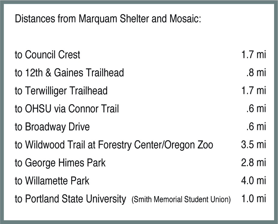
Marquam Shelter to Willamette Park - 3.8 mi. one way
Approaching the shelter from the parking lot, turn to the left and proceed straight on to the Basalt Trail following the sign toward Terwilliger Trail. The trail follows a steep old road, now used as a maintenance road for buried sewer and water lines. After climbing 0.3 miles the Basalt Trail connects to the Marquam Trail. Continue straight on the Marquam Trail. (Marquam Trail also goes to the right, up the stairs, circling around and above the shelter and continuing up to Council Crest.)
The trail ahead traverses a steep slope with many switchbacks before reaching SW Marquam Hill Road. At the guard rail along the road, turn to the right and proceed uphill past the water tank about 150 yards to where the trail crosses the road. The trail continues on the other side of the road where it drops down into the woods toward the east. When you reach the large bridge, you have the choice of continuing straight on the Marquam Trail which leads directly to SW Terwilliger Blvd., about 0.8 miles below. If you go right crossing the bridge onto the Flicker Trail, that will reconnect with the Marquam Trail and take you to Terwilliger in about 0.9 miles.
Cross the road and turn right onto the Terwilliger Trail (paved path). This stretch of the trail follows Terwilliger Blvd. for about 1.1 miles to a wooded area just after crossing SW Capitol Highway. Turn left onto the trail that descends into the woods of George Himes Park. The trail is steep at first and may be muddy. A trail intersection is located part way down. The route bears left and crosses a gully via wooden steps. The trail to the right returns up to the Terwilliger Trail at SW Nebraska Street, the main entry to George Himes Park. The route down to the Willamette River passes under SW Barbur Blvd. and I-5 bridges and drops over several series of wooden steps to SW View Point Terrace. Continue straight on S Iowa St. for four blocks, then right on S Virginia Ave. for three blocks to S Nebraska Street. Turn left onto S Nebraska and follow it into Willamette Park.
Marquam Shelter to Council Crest - 1.7 mi. one way
Approaching the shelter from the parking lot, continue straight up the hill (not to the left, which is the Basalt Trail). Take the first right turn on the Sunnyside Trail. Alternatively, you can take the Shadyside Trail (straight) on the south side of the ravine, which meets the Marquam Trail sooner at the top. You can choose to take one up and the other down. (See a description of the history of this area in the first 2 paragraphs of the North Marquam hike section above.) On the Sunnyside Trail, proceed uphill on the north side of the ravine past the Broadway Trail junction. When you reach the intersection of the Marquam Trail, continue straight following the sign toward Council Crest. In about a hundred yards you will go up a steep switchback to SW Sherwood Drive. As you cross the street, take a moment to look past the house on the left to view the beautiful totem, created by artist Ray Losey. Continue on the Marquam Trail as it crosses a dry creek bed and then look for the hemlock nurse log on the left side of the trail. As you proceed uphill, notice the large number of fir trees blown down in recent storms. The next road crossing is SW Fairmount Boulevard. Be careful crossing here. The next part of the trail is more gradual as it goes up to SW Greenway Ave. Cross Greenway and continue up a steeper 0.2-mile trail to the open field at the dog park on Council Crest. Turn right to ascend to the summit of Council Crest. There you will find a water fountain, trash receptacles, a bathroom, and outstanding views of four Cascade peaks.
Council Crest to Wildwood Trail/Forestry Center - 1.8 mi. one way
From the summit of Council Crest, walk around to the other side of the water tower, cross the loop road and look for the signage for the Summit Trail. Follow this trail down a couple of switchbacks to the Marquam Trail. Turn left, then right onto the paved Council Crest Trail and downhill to the opening at the wooden bollards. At this intersection, cross the street to the left (SW Fairmount Blvd.) then turn right to follow SW Talbot Road downhill. This next stretch of the hike will be on the shoulder of roads for about 0.2 miles. So stay close to the edge of the road as the curve is blind, traffic can be fast, and the street is narrow. When you reach SW Patton Road and the gas station, cross Patton to St Thomas Moore School, and then cross SW Humphrey Blvd. to the right and continue down Patton until you see the trail entrance on your left. On this stretch of the Marquam Trail, descend through the woods for about 0.6 miles until the trail emerges at the Sunset Highway 26 on-ramp.
Walk up the side of the on-ramp, taking care as you cross it, and then across the Highway 26 overpass as far as the sign on the north side of the highway. It will direct you across the street to the left and up into the woods behind the old Children’s Museum. The trail then meanders across small open meadows, where it continues behind the Forestry Center and Vietnam Veterans Memorial and connects with the Wildwood Trail.
North and South Marquam Park Loop - 4.6 mi. round trip
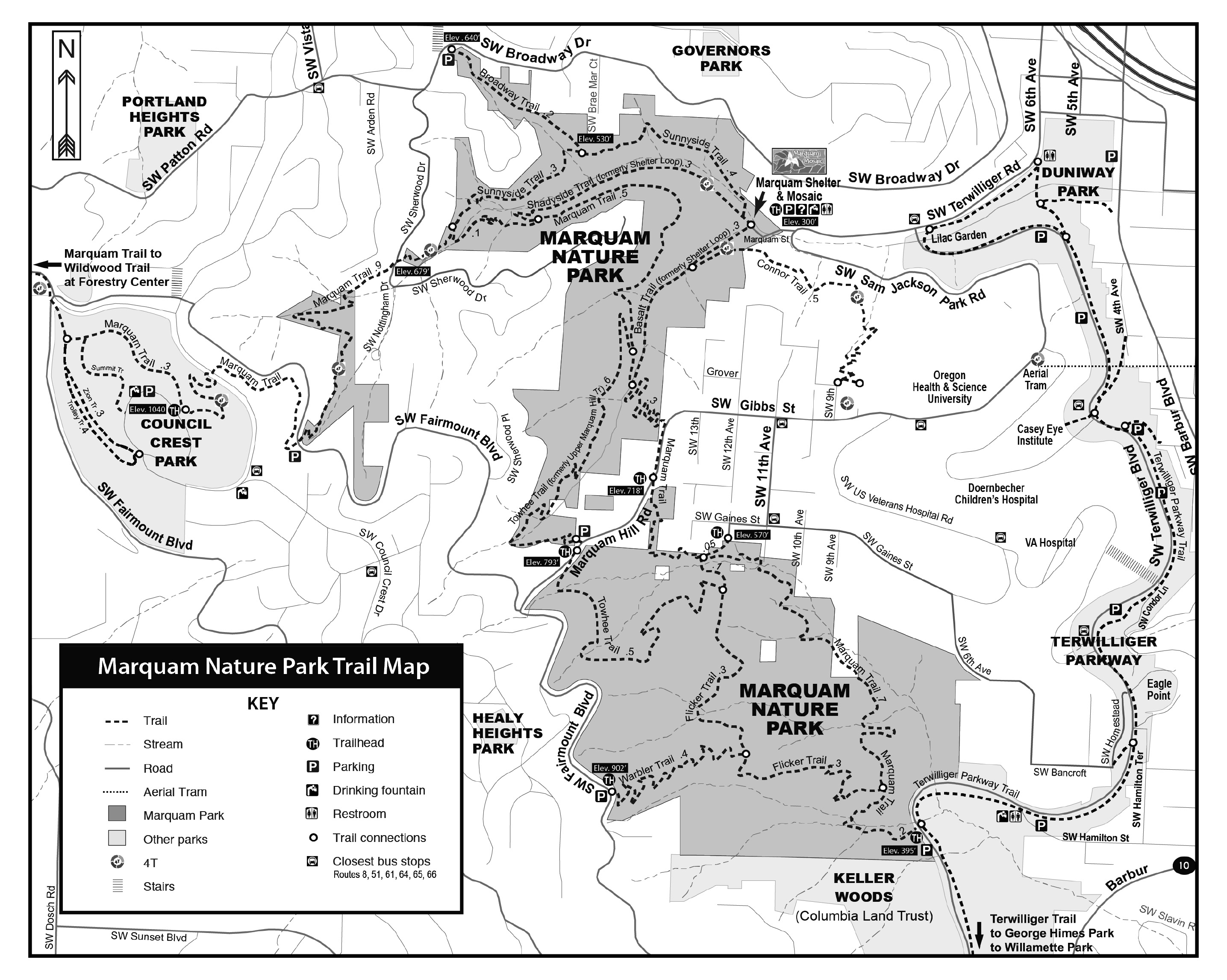
This hike takes you through both major sections of the Marquam Nature Park, i.e., the “North Marquam” and the “South Marquam”, through two different watersheds of Caruthers and Marquam Creeks, and through a short stretch of the Homestead Neighborhood that straddles the two parts of the park. This 4.6-mile loop will take you on the Sunnyside, Marquam, Towhee, Flicker, Connor, and Basalt Trails.
Begin at the Marquam Shelter. Visit the Marquam Mosaic, a 2013 art project that involved over 400 community members, and created the beautiful mosaic walls featuring the flora and fauna of Marquam Nature Park. Proceed up the hill on the trail to the left of the shelter directing you toward Council Crest. About 50 feet up the trail, bear to the right on the Sunnyside Trail, a trail built by an AmeriCorps crew in 1990. As it crosses over to the north (sunny) side of the historic Marquam Ravine (also historically known as the Marquam Gulch), you are crossing over the underground culverted flow of what was originally called Caruthers Creek. This creek was once the source of early Portland’s fresh water supply, which was a primitive network of fir log pipes laid from Marquam Gulch to downtown Portland. The creek is now buried within a sewer pipe that was constructed in 1912. The large 30-inch diameter combined sewer pipe can be spotted in places above ground at the base of the ravine as you walk farther uphill.
At about 0.3 miles you will pass the stairs to the Broadway Trail on the right, which leads in a 1/4 mile up to SW Broadway Drive and a connection to Governors Park. For this hike though, continue uphill on the Sunnyside Trail until the next intersection with the Marquam Trail. Instead of going straight toward Council Crest, you will turn left and head downhill again. After a few switchbacks you will reach the intersection with the Shadyside Trail, but you will continue straight on the Marquam Trail. The trail traverses high on the southern side of the Marquam Ravine and then curves around into the southern ravine of the main part of the park. After about 0.6 miles, at the next intersection, make a sharp right uphill onto the Towhee Trail. This 0.6-mile trail leads to the higher of two crossings of SW Marquam Hill Road. This crossing of the road is also crossing the divide from the Caruthers Creek watershed into the Marquam Creek watershed. After crossing the road, the Towhee Trail descends into another area of the park often referred to as the “South Marquam”. The Towhee Trail will descend 0.5 miles to the Flicker Trail. At the junction, turn right onto the Flicker Trail and continue for 0.6 miles, passing the Warbler Trail intersection and going downhill until the trail meets the Marquam Trail again. If you turn right here, you will reach SW Terwilliger Blvd in about 0.2 miles for a connection to George Himes Park and Willamette Park. Instead, make a left and hike uphill on the Marquam Trail.
In about 0.5 miles you will cross a small bridge over Marquam Creek and notice a much larger bridge uphill over the same creek. Just before the large bridge you will make a right here toward the “12th and Gaines “trailhead entrance to the park. This route does not cross the big bridge but you might take a moment to walk onto the bridge as it is the largest in the park and dedicated when the trail system in the South Marquam was finished in 2013. When you emerge from the park onto SW 12th Avenue you will walk on streets through the Homestead Neighborhood for about a quarter mile to get back into the park. Turn right on SW Gaines St., left on SW 11th Ave., right on SW Gibbs St., and finally left on SW 9th St., the street just after the Plaid Pantry parking lot. You will see a sign at the end of the block identifying the Connor Trail.
The Connor Trail was the dream of the late Dr. William Connor, an Oregon Health Sciences University (OHSU) physician and long-time Friends of Marquam Nature Park board member. Bill wished to have a trail for OHSU employees and guests to have a connection to the park and to get out in the woods. The trail was dedicated in 2007. Through easements, the trail traverses OHSU and private properties to connect to the Basalt Trail below. At the bottom of the Connor Trail, turn right and you will soon return to the beginning of the hike.
North Marquam Hike - 3.6 mi. round trip
This hike will take you up and down both sides of the Marquam Gulch, up to one of the highest points in Portland, Council Crest, and then on some quiet streets through the neighborhood bordering the park before returning to where you started.
Begin your hike at the Marquam Nature Park Shelter on SW Marquam Street. The Shelter is the official entrance to the park and is off the hairpin turn at the bottom of SW Sam Jackson Park Road. Signs say that parking is limited to 2 hours but is rarely enforced.
Take a few minutes to enjoy the interpretive displays and the Marquam Mosaic, a community art project created in 2013. The project, led by artist Lynn Takata and the Friends of Marquam Nature Park, was funded by the Regional Arts and Culture Council. Over 400 community members created the ceramic and glass tile mosaic featuring the flora and fauna of the park.
Behind where the shelter is today, was the planned site in the late 1960s for a 600-unit apartment complex. A small group of neighbors organized and raised funds to buy the property from the developers, build trails, and create the Marquam Nature Park, which was dedicated in 1983. The non-profit Friends of Marquam Nature Park eventually donated the land to the City of Portland and has partnered with Portland Parks & Recreation to maintain what is now over 200 acres of natural area. In 2023, Friends of Marquam Nature Park merged with Forest Park Conservancy which continues the work to preserve this special place.
Begin hiking up the trail behind the shelter toward Council Crest (not the Basalt Trail on the far left.) At the first intersection, continue straight following the Shadyside Trail up the south side of the ravine. In 0.4 miles, the Shadyside Trail intersects with the Marquam Trail. Turn right and hike uphill through a series of switchbacks. Fences were constructed here to keep people and dogs from cutting switchbacks, which tramples plants and causes erosion. The next intersection is where the Sunnyside Trail comes up from the north side of the ravine. Continue left on the Marquam Trail which will soon ascend to SW Sherwood Drive. As you cross the street to follow the trail, look back to the house on the left where you can see some beautiful totem poles, professionally and artfully carved by the homeowner. Proceed on the Marquam Trail until the trail emerges onto SW Fairmount Blvd. You are now leaving Marquam Nature Park and entering Council Crest Park. Cross Fairmount and continue uphill for ¼ mile, crossing SW Greenway Avenue and then making the final 1/4-mile ascent to the top of Council Crest. Enjoy a rest, a bathroom break, or a picnic, and on a clear day, the view of four Cascade peaks from atop one of the highest points in Portland (elevation 1,073 feet).
To continue this hike, walk back to the Marquam Trail on which you ascended. However, when you enter the woods, now make a left onto the Marquam Trail for about 0.2 miles until you go down a few stairs. There, take a right onto the paved path and walk down until you emerge from the park at SW Talbot Road and SW Fairmount Blvd. Take the second right onto SW Talbot Road (not the first right at SW Talbot Terrace). Proceed with caution as there is no sidewalk on this stretch. Pass under the bridge and make a left to stay on SW Talbot Road. There will now be a sidewalk on the east side of the street. Continue about 0.5 miles on SW Talbot Road through a quiet neighborhood until you reach some steps on the right that will take you down to SW Patton Road and a “Benson Bubbler” drinking fountain. Use the marked crosswalk to cross Patton Road and then the crosswalk to the right to cross SW Vista Avenue. You will now be on a short stretch of SW Broadway Drive until SW Ravensview Drive veers off on the left. Walk uphill on Ravensview and make the first right onto SW Corona Avenue, a small street that will dead end into SW Gerald Avenue. Go right on Gerald about 100 yards and look for the SW Trail #6 sign at a staircase on the right. The stairs will take you down to SW Broadway Drive. Cross Broadway with caution and go left a few steps until you reach the Broadway Trail entrance into Marquam Nature Park. Walk down the Broadway Trail for 1/4 mile until it meets the Sunnyside Trail. Turn left and walk downhill 0.3 miles to return to the Marquam Shelter.